The scenario below, loosely based on actual events during and after Hurricane Sandy, illustrates how our rtER app would be used. We envision the rtER smartphone application installed on the phones of people in the National Guard, military reservists, etc., who have some background in emergency response, and who know how to keep themselves safe in a disaster area. Further video would be streamed from the public via other applications, but would lack the guidance system shown in our demonstration video. Assuming a pre-existing communications network (or an alternative channel) can be kept operating, our rtER technology will help improve detection and response time in such critical events requiring urgent attention.
Tuesday, October 30, 2012:
The worst of Hurricane Sandy has already passed through New York City the evening before, leaving widespread damage. The VOST network has been monitoring the damage all night, feeding information to the Public Information Officer (PIO) at an emergency response centre. With the first responders stretched thin dealing with immediate crises, the VOST are key in planning and coordinating the first relief efforts and keeping the public informed and up to date.
Assuming the cell network (or an alternative communications channel) can be kept operating, rtER could help the VOST team with such a disaster as follows:
Violet and Victor, both VOST volunteers, have been tasked with monitoring the situation in Breezy Point. On their screens, they see:
- Twitter feeds, visualized and filtered geographically to the Breezy point area + any other tweets with hashtag #BreezyPoint
- Video feeds from the area, visualized geographically on an interative map and linked to a grid where they can be organized based on priority.
In January 2013, a 48-inch water main broke at the top of the hill that descends into downtown Montreal, right through the main McGill campus. There was massive flooding through all of the streets and into many of the buildings on the surrounding campus, with black ice underneath, making it practically impassable in many spots. The campus was almost completely surrounded by water making it challenging to find a way off campus.
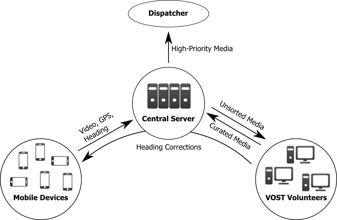
more...The long-term objective involves distribution, registration, and interaction with static and live multimodal data sets collected from heterogenous sensors (statically positioned video cameras, multispectral imaging devices, smartphones deployed in the field, audio feeds, and even social community reports) to facilitate the task of emergency and disaster responders and their operations centers.
more...Our development efforts were focused on three key components during the second development round: an Android app that records and uploads live video streams, a central server that stores these video streams and their metadata along with various other content types, and a web client that allows for the synchronized collaborative sorting and curation of the content stored on the server, along with several additional helpful features.
In the third round, our efforts included video streaming, iOS port, and significant functionality additions in response to feedback from users in the emergency response community.
The typical use case for the mobile app places someone with a smartphone on site in a disaster scenario, primely located to provide relevant contextual data to emergency responders, possibly filtered by virtual volunteers. By opening the rtER mobile app, the smartphone user can stream a video feed, deemed to be relevant, which will immediately appear as a live tile to VOST volunteers, connected to the rtER web client, where it can be sorted based on its situational importance.
more...